Bridleway 11
Direction roughly N - S;
Distance c.900m.
![]()
![]()
![]()
![]()
![]()
![]()
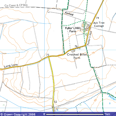
![]() Bridleway 11 runs along part of the eastern
edge of Gamlingay’s parish boundary with Little Gransden. It starts at the
corner of Long Lane, just after Crooked Billet Farm (267531) almost on the top
of Fuller’s Hill at about 76 metres above sea level. It runs down the gentle
slope along the eastern side of the hedge for about 400 m. Aerial photographs
show a square enclosure in the field to the south of the farm (SMR 5369
TL255512). This was a plot of land surrounded by raised earth banks in which
animals, most probably sheep, could be kept. This field used to belong to the
Queen in 1601. Thomas Langdon’s map in March of that year stated that it was
farmed by Thomas Sherman. The next field was owned by the Avenelles. The field
to the west was known as Broade Leaes. and to the east was
Parte of Grannefden Fielde.
Bridleway 11 runs along part of the eastern
edge of Gamlingay’s parish boundary with Little Gransden. It starts at the
corner of Long Lane, just after Crooked Billet Farm (267531) almost on the top
of Fuller’s Hill at about 76 metres above sea level. It runs down the gentle
slope along the eastern side of the hedge for about 400 m. Aerial photographs
show a square enclosure in the field to the south of the farm (SMR 5369
TL255512). This was a plot of land surrounded by raised earth banks in which
animals, most probably sheep, could be kept. This field used to belong to the
Queen in 1601. Thomas Langdon’s map in March of that year stated that it was
farmed by Thomas Sherman. The next field was owned by the Avenelles. The field
to the west was known as Broade Leaes. and to the east was
Parte of Grannefden Fielde.
Bridleway 11 formed part of Gamlingay’s
‘Procession’ or ‘Perambulation’ way. The tradition of beating the bounds,
walking in procession around the parish boundary was widespread across Europe
and only came to an end during the reign of Queen Elizabeth I. Proceffion
Waye and Procession balke are marked on the 1601 map. The booklet, Gamlingay’s
Procession Waye, can be found in the library. Balke is another
spelling of baulk, an unploughed strip of land between two furrows, often with
low raised banks on either side made up of stones picked from the field.
Medieval farmers took advantage of the gradient and ploughed up and down the
hill. Today this technique is frowned upon. Contour ploughing reduces the
incidence of rainwater washing the soil down the plough furrows.
After about 400 m. the track reaches a
hedge where, according
to the Sites and Monument Record, the Gransden Cross and Gamlingay Cross used
to stand only a few metres from each other at the junction of the parishes of
Gamlingay, Little Gransden and Hatley St George. However, only the ‘Gransden
Crosse’ is marked on Langdon’s 1601 map. They were both on the south-facing
slope of Fuller’s Hill where the parish boundary, now a public bridleway, goes
around the corner of a field in a dog’s leg. Gamlingay Cross was referred to as standing at the southwest
corner of the field where the boundary turns to the east (SMR 02398; TL
26805260). Gransden Cross is a few metres further east where the parish
boundary turns to the south (TL 26805270).
It was the tradition during the Procession walk to stop at these crosses
and read a chapter from the New Testament, The first chapter of Mark’s gospel
was read at the eastern cross. The
S.M.R. also refers to both crosses being at the junction of the north-south
Procession Way and the east-west Royston Way. Little Gransden’s southern parish
boundary runs east-west and was marked on Langdon’s map as ‘Royston Waye’, the
route southeast through Hatley St George and Croydon down to Royston.
The track then turns south again along what
was marked on the 1601 map as Mr Turpin’s land in Hungrie Hatley fielde
for about 500 m. towards the disused Cambridge to Oxford railway line. You can
see a long embankment stretching ENE and the path goes over the track and ends
where it crosses the railway bridge over Millbridge Brook (270523) at 55 m. It
continues to the SE towards Hatley St George as Bridleway 2 and south to the Hatley
Road as Bridleway 1 when it crosses
the brook. Mr Astor, the owner of Hatley Park, used the long stretch of open
ground between Millbridge brook and the embankment of the railway line as a
gallop for his racehorses.
In 1657 there was grazing in
the parish for 200 sheep (C.U.L. Doc.1444). Some inclosure (fencing off) of the
demesne may have been effected by 1601, when land in Gamlingay belonging to
Hatley St George manor was said to have been enclosed (V.C.H. Cambs. Vol. ii, p.77).
About 1793 farming was mixed, and wheat,
black oats, peas, and clover were grown together with barley and turnips on the
better land. The whole parish was inclosed by then; it is not known when the
process was completed. In the north-east of the parish there were about 100a.
of ’very rich and luxuriant herbage’ and in all about half of the land appears
to have been permanent grass. A rotation of two crops and a fallow was
followed, as specified in the tenants’ leases. The leases were short, running
for between 3 and 12 years, and giving no encouragement to the farmers to
improve drainage. An acre was said to produce either 17 bu(shels – about 1.24
cubic feet) of wheat or peas and beans or 22 bushels. of barley or oats.
It is probable that ‘Heylegrange’ which
belonged to Sawtry Abbey (Hunts.) stood in the north part of the parish by the
boundary with Little Gransden (??Crooked Billet Farm) In 1839 there were three
farmsteads standing well north of the road, Hill Farm, its subsidiary farmhouse
called Cottage Farm, and William Ingle’s farmhouse (C.R.O. P88/27; R50/20/4),
probably known as Broad Leys in 1851 (H.O. 107/1758). All three farmsteads had
disappeared by 1918 (C.U.L. Maps 53 (1)/91/158).
Before 1164 Sawtry Abbey (Hunts.) had been
granted the ‘grange’ of Hatley (B.M. Cott. MS. Aug.ii,116). In 1279 the abbot
of Sawtry held a messuage called Heylegrange with 130 a. in free alms in Hatley
St George by the gift of an ancestor of Helen, wife of Ellis of Gledseye (Rot.Hund. (Rec. Com), ii, p.539). In
1316 Heylegrange, together with land in several neighbouring parishes, was
leased to Simon of Bourn for life by the abbot (B.M. Harl. Ch. 83 A.39).