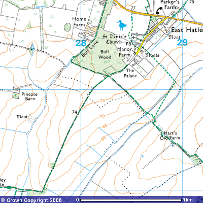
Bridleway 15 (East Hatley)
Direction: NE –SW Distance: c.450 m.![]()
 Back to map
![]()
![]()
![]()
![]()
![]() Bridleway 15 is an ancient track that starts at the south end of the
village street in East Hatley, just past The Palace (TL 285503). It follows the
crest of a ridge, 76 metres above sea level, west-southwest along the
southeastern side of Buff Wood. This private woodland is a Site of Special
Scientific Interest on the glacial boulder clay dumped by the retreating ice
cap over 11,000 years ago.
Bridleway 15 is an ancient track that starts at the south end of the
village street in East Hatley, just past The Palace (TL 285503). It follows the
crest of a ridge, 76 metres above sea level, west-southwest along the
southeastern side of Buff Wood. This private woodland is a Site of Special
Scientific Interest on the glacial boulder clay dumped by the retreating ice
cap over 11,000 years ago.
In the southeast of the wood is the moated site of the Quy family manor house. According to the Victoria County History this manor dates back to shortly after the Norman Conquest:
MANORS. The 8 sokemen (men who had the privilege of holding
court, usually connected with the feudal rights of lordship) who had held 2
hides (area of land between 120 and 240 acres, 48 to 98 ha.) in 1066 still
occupied them in 1086 under Picot the sheriff, who had obtained the land by
exchange (V.C.H. Cambs. i.392-3). His lordship
descended the cadet line (?) of Picots established at Quy (Cambs.), who
probably subinfeudated (in the feudal system, the
leasing of a portion of the land held by a feudal lord's servant vassal (who owed a service in return) to somebody else who became the servant's servant in turn) the Hatley fee
before 1185 (cf. Rot. De. Dom. (Pipe R.
Soc. xxxv), 86; Red Bk. Exch. (Rolls Ser.) i.363,370). (Under the system of feudalism, a
fiefdom, fief, feud, feoff, or fee, often consisted of heritable
lands or revenue-producing property granted by a liege lord in return for a
form of allegiance, originally often to give him the means to fulfil his
military duties when called upon. However anything of value could be held in
fief, such as an office, a right of exploitation (e.g., hunting, fishing) or a
revenue rather than the land it comes from.) Their overlordship passed
with Quy manor (in south-eastern part of Buff Wood) after 1220 through two
successive heiresses to the Traillys (Farrer,
Feud. Cambs. 124-6. There was a Geoffrey de Trailly, thought to be from
Trelly, near Coutenance, France, mentioned in the Domesday Book for
Chellington, near Odell, Bedfordshire and a Nicholas de Trailly in Old Warden
in Bedfordshire in 1199), whose rights over Hatley were still recorded in the
14th century (e.g.
P.R.O. SC 5/Cambs. Tower ser. No. 16. rot. 15; Cal. Close, 1288-96, 159; Bk. of
Fees, ii. 922).
In the early 13th century EAST HATLEY manor had been held of them
(the Traillys) with land at Quy as ½ knight’s fee. William (fl.1205), son of
Geoffrey of Quy (Cur. Reg.
R.. ii. 272; iii. 310), was perhaps the William of Quy who held ½ hide at
Hatley in 1235 and 1242 (Liber de
Bernewelle, 246-7; Bk. of Fees, ii. 922; P.R.O., CP 25(1)/24/16, no.22). Sir William of
Quy held land there c.1260 (B.L.
Add. Ch. 6293; B.L. Lansd. MS. 863, f.61v). John, son of William of
Quy, was tenant of the Traillys between 1267 and 1290, when his land in Hatley
was ¼ fee. By 1279 he also held of Beatrice de Andeville (There was a Beatrice
de Andeville b.1245, of Clopton Manor, Stratford upon Avon. She married Sir
Robert Hoo of Luton.) 60 a. (Cal. Pat. 1266-72, 149; P.R.O., SC 5/Cambs. Tower ser.
No. 16, rot. 15; Feud. Aids. i. 136; Cal. Inq. p.m. ii, p.483) which the
Andevilles had still held in demesne (land, often in the country, kept for
owner’s own use) c. 1235 (cf.
R.R.O., CP 25(1)/24/16, no. 22). It probably represented the demesne of 1 ¼ hide at
Hatley held in 1086 of Eudo the steward by Beatrices’s ancestor Humphrey de
Andeville, lord of Clopton, with which it had descended (V.C.H. Cambs. i. 384). (It would be interesting
to determine the link between Clopton, Warwickshire and Clopton, Cambs.) John’s
son, John of Quy, was lord of Hatley between 1302 (Feud.
Aids. i. 151, 156) and 1327 (Cambs.
Lay Subsidy, 1327, 47), and he or a namesake held the manor in 1346 (Feud. Aids. i. 172; Palmer, Hist. Clopton, 59; Cal. Pat.
1345-8, 229).
The family has not been traced later. A fraction of the Trailly fee, styled
1/8th fee, acquired in or before 1300 by Hugh Clopton, passed with his manor of
Rowes in Clopton (Cal. Inq.
p.m. iv, p.250; Feud. Aids. i. 151, 172, 190). In 1428 the former ¼ fee
of the Quys was divided equally between John Clopton and John Hoo (Feud. Aids. i. 190).
(V.C.H. West. Cambs. Vol.II, pp.43-44)
![]()
More details about the parish can be found in the Victory County History
account of East Hatley. It states that:
The rectory house formerly stood within a moat just south of the manor house (Downing maps 1750). In the 1660s it had 4 hearths (P.R.O., E 179/244/22, f. 31v). it was dilapidated (falling down) in 1722 (C.R.O., P 151/1/2/, at end), and although inhabited by the rector in 1728 and 1775 (B.L. Add. MW 5828, f. 90; C.U.L., E.D.R., C 1/1), was described in 1807 as a miserable cottage, unfit for a clergyman’s family (C.U.L., E.D.R., C 1/4). It was burnt down in 1821 and not rebuilt (C.R.O., P 152/1/2, at end), the incumbents thereafter living in Tadlow.
(Ibid. p.47)
The Royal Commission of Historic Monuments includes details of its
dimensions.
(14)
MOATED SITE (Class A 1(b); N.G. TL 28355020), not on O.S.), at the S.E. corner
of Buff Wood. The moat is trapezoidal, 260 ft. N.W. by 225 ft. N.E. by 294 ft.
S.E. by 167 ft. S.W. the wet ditch is 20 ft. to 30 ft. wide, 3 ft. to 5 ft.
deep and 15 ft. to 18 ft. across at the bottom. On three sides are counterscarp
banks 20 ft. to 30 ft. wide and 6 ins. To 3 ft. high. There is a causeway 25
ft. wide in the S.E. side with cupped and slightly staggered ends to the ditch
on either side. The interior is irregular, with two slight ponds near the E.
angle; the whole site is thickly overgrown.
(R.C.H.M.
(1968), Inventory Vol. I, West Cambs. p. 150)
Bridleway 15 is an ancient track leading down the valley towards Tadlow.
After about 300 metres it crosses Bridleway 14 that runs west along the south
side of Buff Wood to Buff Lane and the deserted medieval village of Pincote
Manor and east-southeast across the valley towards Hart’s Old Farm and Croydon.
Bridleway 15 ends about 200 metres further on where it crosses the parish
boundary between East Hatley and Tadlow (TL 281499). The track continues
southwest as Bridleway 3 towards New England Farm and Tadlow.