Bridleway 18 (East Hatley)
Direction: SSW – NNE Distance: c.1,800 m. Back to map
BW18 FP7 BW18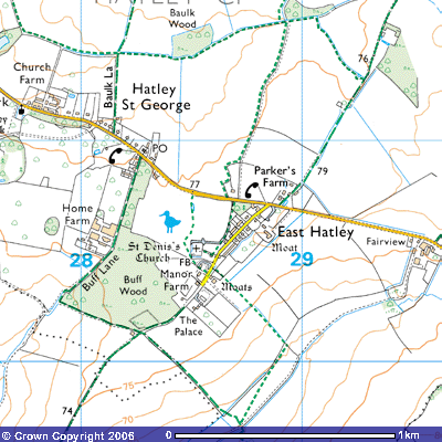
Bridleway 18 is an ancient track leading from East
Hatley village green north-northeast to Hatley Wilds, Longstowe and Ermine
Street, the Roman Road from Royston to Godmanchester. The predominantly mid-19th
houses on the village street were constructed on the eastern side of the
triangular village green. Its southerly apex was the manor house and St Denis’
Church. Bridleway 18 starts a about 78 metres above sea level on the northern
side of Hatley Road, about 100 metres east of the junction with the village
street. It follows a track past Parker’s Farm, a tall red bricked farmhouse
built in the late 19th century,
rising to 79 metres above sea level and then follows the western side of
a drainage ditch down across the fields to the northeast.
After about 700 metres it meets Footpath 7 (TL), a long path which follows the course of Millbridge Brook west into Hatley St George. Just to the west of the bridleway there is a pond (TL 293513). This is a spring at 75 metres above sea level., one of the sources of Millbridge Brook.
Bridleway 18 then
ascends a gentle slope for about 250 metres and passes a small copse to the
east where it veers slightly to the northwest, past Long Lane Farm which was
added to Parker’s Farm in the 1860s. According to the Royal Commission of
Historic Monuments :
LONG LANE FARM (Class J),
two-storeyed, framed and plastered, with hipped slated roof, is 18th
century. The traditional design is elaborated to include a narrow staircase by
at the S. end and an outshut of indefinite extent on the E; an early 19th
century addition now occupies the S. end of this side.
(19) CULTIVATION REMAINS in the former parish of East Hatley (not on O.S.). Ridge and furrow, up to 300 yds. long with ridges 7 yds. to 12 yds. wide and 9 ins. to 1 ½ ft. high with headlands of 9 yds. to 12 yds. survives over most of the parish though some has been ploughed since 1946, notably in the closes round the village and in the N.E. of the parish. The longest ridges are almost certainly the result of ploughing two or more former end-on furlongs as one. In the N.E. of the parish the ridge and furrow fits the rectangular field lay-out; around Long Lane Farm (Monument 10) (N.G. TL 294515) and Carter’s or Holben’s Farm (Monument 9) (N.G. TL 296505) curving open field furlongs have been enclosed en bloc.
(R.C.H.M. (1968),
Inventory, West Cambs. p. 150)
After a further 200
metres you meet Footpath 3 to the west which zig-zags its way . About 400
metres you meet Bridleway 20 (TL298519) at 82 metres above sea level., the
highest point in the parish. From here there are panoramic views across the
county as this area is also the highest in West Cambridgeshire. The land is
heavy boulder clay, laid down during the last ice age which only melted about
11,000 years ago. Beneath it lies many hundreds of metres of Gault clay,
deposited when this area was under the sea about 500 million years ago and
about 27o south of the Equator. The whole area was covered in trees
until the first settlers began clearing it.
This route takes you
north-northwest towards Hayley Wood, an ancient woodland. Bridleway 18
continues for a further 300 metres, passing another plantation to the
southeast. About 100 metres along the plantation you meet Bridleway 22 (TL
298521) This takes you north around the eastern side of Hatley Wilds. About 200
metres further on the bridleway ends where it meets the parish boundary between
East Hatley and Longstowe. (TL 299522) along which runs Bridleway 21. The track
continues north-northeast along Croydon Old Lane to meet Ermine Street, the Old
Roman Road at Coombe Grove farm. There
are several moats in the fields nearby. These are the remnants of deserted
medieval manors referred to in the Victoria County History..