Bridleway 4 (Tadlow)
Direction: E –W
Distance: 600 m. Back to map
![]()
![]()
![]()
![]()
![]()
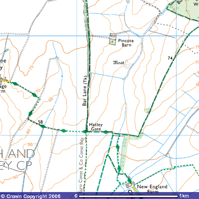 Bridleway 4 is to the southwest of East Hatley and is a continuation of
Bridleway 3, the track running south-southwest out of the village. It starts at
the corner of a copse (TL 276490) at about 58 metres above sea level, on a
gently sloping ridge with 270o views across the Rhee valley. It
follows the south side of the copse for about 300 metres eastwards along the
south side of a mature hedge with views south down the slope towards the
Mordens, Ashwell and the Royston Downs on the horizon. After about 300 metres
it meets Footpath 9 which runs down the dry chalk valley towards New England
Farm and Tadlow.
Bridleway 4 is to the southwest of East Hatley and is a continuation of
Bridleway 3, the track running south-southwest out of the village. It starts at
the corner of a copse (TL 276490) at about 58 metres above sea level, on a
gently sloping ridge with 270o views across the Rhee valley. It
follows the south side of the copse for about 300 metres eastwards along the
south side of a mature hedge with views south down the slope towards the
Mordens, Ashwell and the Royston Downs on the horizon. After about 300 metres
it meets Footpath 9 which runs down the dry chalk valley towards New England
Farm and Tadlow.
![]()
![]()
About
100 metres further west it crosses a footbridge over a stream, on the other
side of which it meets Bridleway 24 which runs south-south-west towards Grange
Farm on the Tadlow Road. The bridleway then ascends a gentle slope for a
further 300 metres along the south side of the hedge until it reaches the
junction of Bridleway 1 and Footpath 5 at Hatley Gate (TL 271490), about 62
metres above sea level. Bridleway 1
(Bar Lane) takes you north through Hatley Park onto the Hatley Road. Footpath 5
takes you south onto the Tadlow Road.