Footpath
11 (East Hatley)
Direction:
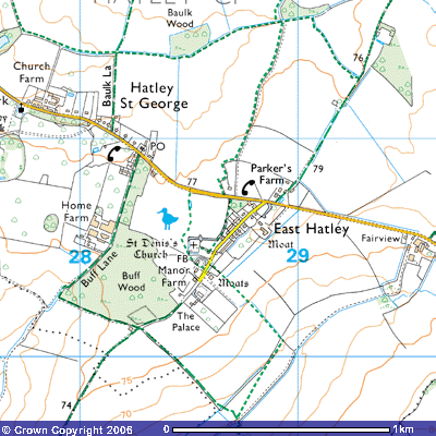
S - N Distance: c.400 m. Back to map
FP11 FP9
 Footpath
11 starts at about 76 metres above sea level, close to the southern end of East
Hatley village street, at the entrance to Manor Farm (TL 286504). According to
the Victoria County History for Cambridgeshire, the original moated manor house
was built by Robert Castell, towards the end of the 15th century.
There are records of his father, also called Robert, in the parish in 1480. The
manor of 550 acres was acquired by 1490. It was said in 1660 to be an ancient
timber-framed building. Castell and his descendents lived there until 1661 when
it was sold to Sir George Downing, the spy, diplomat and politician, reputed to
have been one of the wealthiest men in 17th century England. It was
then remodelled as a fine country house but, after his grandson, Sir George
Downing III, inherited the estate in 1684, he had the East Hatley manor house
dismantled and its timbers and bricks transported to be used in the
construction of a grand mansion in Gamlingay Park in 1712. Three sides of the
moat still exist in the garden of the house to the north. Recognised as an important site, the Royal Commission
of Historical Monuments reports
Footpath
11 starts at about 76 metres above sea level, close to the southern end of East
Hatley village street, at the entrance to Manor Farm (TL 286504). According to
the Victoria County History for Cambridgeshire, the original moated manor house
was built by Robert Castell, towards the end of the 15th century.
There are records of his father, also called Robert, in the parish in 1480. The
manor of 550 acres was acquired by 1490. It was said in 1660 to be an ancient
timber-framed building. Castell and his descendents lived there until 1661 when
it was sold to Sir George Downing, the spy, diplomat and politician, reputed to
have been one of the wealthiest men in 17th century England. It was
then remodelled as a fine country house but, after his grandson, Sir George
Downing III, inherited the estate in 1684, he had the East Hatley manor house
dismantled and its timbers and bricks transported to be used in the
construction of a grand mansion in Gamlingay Park in 1712. Three sides of the
moat still exist in the garden of the house to the north. Recognised as an important site, the Royal Commission
of Historical Monuments reports
(6) MANOR FARM (Class U), two-storeyed, of stuccoed
brick with hipped slated roof, stands on the moated site (Monument (16)) of the
manor house of the Castell family, demolished c. 1685. The house, ostensibly 19th
century, incorporates earlier work, the bulk perhaps of the 17th
century, but including an 18th century stair, the balusters of which
are cased (It was replaced by 2005 with 21st century oak); also most
of a small 15th or early 16th-century tie-beam truss comprising
a stop-chamfered and cambered tie-beam with the sawn-off tenons (A projection on the end of a piece of wood shaped
for insertion into a mortise to make a joint.) of some ceiling joists, two solid braces and the
stop-chamfered swell heads (?) of two supporting posts.
(16) MOATED SITE (Class A1 (a); N.G. TL 285504), at Manor
Farm (Monument 6), on level boulder clay 260 ft. above O.D., being that of the
manor house of the Castell family demolished c. 1685 by the second Sir George Downing
(Lysons, Cambridgeshire, 201 and 209); the material was later used at Gamlingay
Park (see GAMLINGAY) (61), a rectangular area 200 ft. N.E. to S. W. by 100 ft.
is partly enclosed by a wet ditch 32 ft. to 45 ft. wide and 3 ½ ft. deep. This
has been partly filled but still complete in 1750 (map in Downing College).
There is a causeway 40 ft. wide across the S.E. side. At the S. angle is an
apparent approach leat (water channel), 2 ½ ft. deep still partly wet.
(R.C.H.M.
Inventory, West Cambs. p.150)
The
southern side of the moat has been filled in. The present Manor Farm is a
recently renovated, mostly 19th century farmhouse, contains some
timber frames that date back to the 16th or 17th century.
The
first section of the walk is through private property, between the house and
the garage. It follows the fence on the northern side of the back garden west
for about 100 metres and then crosses a foot bridge over a drainage ditch into
a meadow. To the east you can see the remains of St Denis’s Church. In the
field are some earthworks referred to in the Royal Commission of Historic
Monuments:
(17) MOUND (N.G. TL 28715059, not on O.S.), to N.W. of East Hatley village street, on ground formerly part of the village green, now pasture; circular, 40 ft. across and 2 ft. high; approached on the W. by a hollowed track 15 ft. wide and about 6 ins. deep.
… Remains of former house sites and of wet ditches round their crofts, set back some distance from the present street, indicate that the village formerly consisted of a triangular green with its base towards the N., 50 yds. to 70 yds. beyond the modern road, and its apex between the moats of The Palace and Manor Farm (Monuments 15 and 16). The green was presumably formed by the convergence of two roads, one from the N.E., which can be traced as a disused track, known as Long Lane or Croydon Old Lane, leaving Ermine Street at N.G. TL 31835355, and one from Longstowe in the N., called Hayley Lane, now only a footpath. To the S.W. of the green the road led first S.W. and then S. through the abandoned settlement of Pincote (See Tadlow 9) to Tadlow. W. of the green are a number of possible house sites. At N.G. TL 28605055, to the N.E. irregular scarps 9 ins. to 1 ft. high cover an area 350 ft. N. to S. by 150 ft.; banks 30 ft. wide and 1 ft. high separate them from ridge and furrow to the W. at N.G. TL 28605055, to the N.E. of the church, is an area 400 ft. E. to W. by 250 ft. bounded on the S. by a wet ditch, 30 ft. wide and 2 ½ ft. deep, which joins a stream on the E. A projection N. from this ditch divides the area into two unequal parts. Recent ploughing has turned up the footings of an 18th century brick wall and of brick buildings, cobbles and 13th to 18th century pottery.
.
(R.C.H.M.
(1968), Inventory Vol. I, West Cambs. p. 150)
The
footpath then follows an irregular route north for about 300 metres past a
small pond to meet Hatley Road at 77 metres above sea level (TL 285507).
Other Hatley stories:
The History of Hatley
St George in Victoria County History
The History of East Hatley
in Victoria County History
The Royal Commission of
Historic Monuments account of East Hatley
Downing
College’s 1978 pilgrimage to East Hatley
Hatley articles written by Ishbel Beatty
The Man who
lived in the Palace