Footpath
12 (East Hatley)
Direction:
E - W Distance: c.150 m. Back to map
FP7 FP9 FP9 BW18![]()
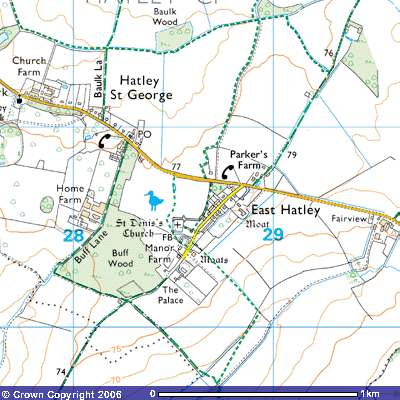
Footpath 12 is the route from the village
street of East Hatley to St Denis’s church. It starts at about 76 metres above
sea level. According to the Victoria County History of West Cambridgeshire:
In 1086 the vill (hamlet) had 21 peasants
and 3 servi (? slaves) (V.C.H. Cambs. v. 415-16). There were probably 19 taxpayers in 1327 (Cambs. Lay Subsidy, 1327, 47) and 23 for the wool levy in 1347 (Palmer, Hist. Clopton,
58-9. For 1377 population, cf. above, Croydon intro.). By the 16th century the population
had shrunk. There were 10 taxpayers in 1524 (P.R.O., E 179/81/129, m.2) and 9 households in 1563 (B.L. Harl, MS. 594, f. 198). The 10 or 11 houses of 1662 were reduced
to 8 by 1674 (P.R.O.
E 179/84/437, rot. 49; E 179/244/23, rot. 47). There were 50 adults by 1676 (Compton
Census), and 75 people in 17 families in 1728 (B.L. Add. MS. 5828, f. 90). Numbers were probably even lower c.1750
(C.R.O.,
par. Reg. TS). From
1801 to 1841 the population varied around 100, suddenly rising to 146 by 1846
by 1851. from a peak of 155 in 1871 it fell to 124 by 1891, fluctuating
thereafter between 70 and 100 until the 1950s (Census, 1801 – 1971).
The medieval village lay around a
triangular green, widening slightly from its south-eastern apex, by which stood
the church, parsonage and principal manor house. The green lay where a track
running north-east from Pincote hamlet in Tadlow divided to lead
north-north-east towards Hayley wood in Little Gransden, and north-east along
Long, or Croydon Old, Lane towards Longstowe. Along the two longer sides of the
green lay many small tofts (Viking word for house with building and land)
within moats often still wet, from which crofts (small farms) stretched back (R.C.H.M. Cambs. i. 149-52). After the final inclosure c. 1670 the
village was largely cleared away (to create sheep pasture). For some time the
only dwellings in the parish were eight farmhouses scattered through the
fields, such as the surviving timber framed Long Lane Farm, and Hatley Wilds
Farm, partly of brick, in the far north, and their dependent cottages (Ibid. 150; all illustrated
on Downing maps 1750).By
1750 there survived at the site of the village, then called Town closes, only
the parsonage and a farmhouse at each end of the green, incorporated as Walnut
Tree close into the Downing family estate (Downing maps 1750). The area round the green was almost
equally empty in 1842 (C.U.L.,E.D.R., G, tithe map 1842). Small houses began to be built actually
on the old green from the 1850s, and by 1871 the parish contained 6 farmhouses,
c. 12 cottages at the green, and the ‘Palace’, a high, gaunt house at its
south-west end, erected for members of Downing College to occupy while
supervising the College estate (P.R.O., RG 10/1577; Cambs. Ind. Press, 1st
Dec. 1961). In the
1970s c. 14 new houses filled a wide gap between the 19th century
housing at each end of the green (cf. Cambs. Evening News, 17th Oct. 1974;
4th Feb. 1977)…
Along the two longer sides of the green lay
many small tofts (Viking word for house with building and land) within moats
often still wet, from which crofts (small farms) stretched back (R.C.H.M. Cambs. i. 149-52). After the final inclosure c. 1670 the
village was largely cleared away (to create sheep pasture)… By 1750 the
survived at the site of the village, then called Town closes, only the
parsonage and a farmhouse at each end of the green, incorporated as Walnut Tree
close in the Downing family estate (Downing maps 1750). The area round the green was almost
equally empty in 1842 (C.U.L.,E.D.R., G, tithe map 1842). Small houses began to be built actually
on the old green from the 1850s, and by 1871 the parish contained 6 farmhouses,
c. 12 cottages at the green, and the ‘Palace’, a high, gaunt house at its
south-west end, erected for members of Downing College to occupy while
supervising the College estate (P.R.O., RG 10/1577; Cambs. Ind. Press, 1st
Dec. 1961)… In the 1970s c. 14 new houses filled a wide
gap between the 19th century housing at each end of the green (cf. Cambs. Evening News, 17th Oct. 1974; 4th Feb.
1977).
(V.C.H. West Cambs. Vol. II, pp.43-44)
Details of its architecture were included in the Royal
Commission of Historic Monuments:
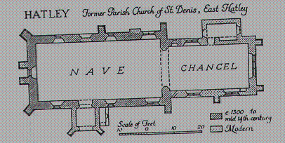
ECCLESIASTICAL
1.
Former PARISH CHURCH of ST. DENIS, East Hatley,
stands in the middle of a square churchyard which is bounded by ditches to the
N., W. and S., that to the N. being wet (see Moument 18). The walls are of
field stones with clunch and freestone dressings; the roofs are tiled. The
fabric consists of a chancel, almost entirely rebuilt and lengthened in the
course of a general restoration by Butterfield in 1874, with a small modern
vestry; and nave, of c.1300 but with some apparently rather later detail, and
with rebuilt S. porch. The building is now derelict, a small replacement having
been recently built to the E. on the other side of the village street.
Architectural
Description – The W. extremity of the N. wall of the chancel is old and retains
a blocked square-headed ‘low-side’ window with a chamfered (grooved, fluted)
surround. The chancel arch has been rebuilt but some dressings have been
reused, including the moulded caps to both responds (A pilaster or half-pier
engaged to a wall and carrying one end of an arch or groin, often at the end of
an arcade). Of c. 1300.
The nave (45 ½ ft. by 21 ft.) is probably
of c. 1300, although some of the openings look a little later. There are three
windows in the N. wall; the first of two trefoiled (three leaves) lights with a
quatrefoil (four leaves) in the head, is restored and has modern splays (An
oblique angle or bevel given to the sides of an opening in a wall so that the
opening is wider on one side of the wall than on the other) and rear arch; the
second and third, both somewhat restored, are lancets (an acutely pointed
Gothic arch, like a lance), the second with a cinquefoil (five leaves), the
third with a trefoiled head. The three windows on the S. side resemble those
corresponding to them on the N. and are somewhat restored; the W. window
resembles the middle windows of both side walls and is set between restored
buttresses rising to the rebuilt bellcote. The N. doorway is of two continuous
chamfered orders; the mid-14th century S. doorway is of two
continuous wave-moulded orders separated by a threequarter hollow. The nave
roof is modern.
Fittings – Bell: formerly in bell-cote over
W. gable (Raven, Church Bells of Cambs., 150); sold for scrap, 1964. Brasses:
formerly in nave, towards E. end (Mill Stephenson, Monumental Brasses (1926),
61, (1) female figure, now removed to new church. The matrix remains with
indents for a male figure and also for three shields, described by Mill
Stephenson, which have recently been stolen. In nave (2) of Constance, wife of
Robert Castell, 1610, rectangular inscription plate (“She was very kinde and
liberall to all that feared God and mercifull to the poorer’). Glass: in
tracery of first window on N. side of nave, small rounded with fleur-de-lis
framed in red and blue; medieval. Monuments and Floor slab. Monuments: In
vestry – on N. wall (1) of Francis Say, 1705, clunch tablet with shield of
arms; on W. wall (2) of Francis Say 1796, lozenge-shaped tablet. In nave on W.
wall (3) of rev. William Cray Say, Rector, 1751, white marble tablet. Floor
slab: in nave, towards E. end, much worn and largely illegible, apparently that
of Robert Castell, 1665 (Palmer, Inscriptions and Arms from Cambs., 43).
Niches: in nave, mutilated and rest on either side of the chancel arch, similar
but not uniform, with hollow-chamfered jambs (vertical posts/columns) and
cinquefoil ogee (A double curve with the shape of an elongated S) heads; 14th
century. Plate: includes silver-gilt cup and paten, London 1684. Scratching: on
E. jamb of S. door, ‘I H S’ perhaps 14th century. Miscellaneous:
reset over S. door, cartouche of arms of Downing impaling Howard and oblong
date panel inscribed ANoDOM 1673’ (plate 126).
(R.C.H.M. (1968), Inventory, W. Cambs.
p.146)