Footpath 3
Direction: E – W Distance:
c.200m
![]()
![]()
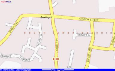 Footpath 3 is a shortcut
between Stocks Lane and Mill Street. In medieval times it was part of the route
east out of Gamlingay up Long Road (Station Road), the road to Hatley St George
and East Hatley, Croydon and onto Royston of Cambridge. On Thomas Langdon’s map
of Gamlingay, drawn up in 1601, it shows it running between two fields
belonging to Charles Cooley.
Footpath 3 is a shortcut
between Stocks Lane and Mill Street. In medieval times it was part of the route
east out of Gamlingay up Long Road (Station Road), the road to Hatley St George
and East Hatley, Croydon and onto Royston of Cambridge. On Thomas Langdon’s map
of Gamlingay, drawn up in 1601, it shows it running between two fields
belonging to Charles Cooley.
A signpost (239523)
indicates its start on the opposite side of Stocks lane to the cemetery and the
Fire Station. There’s staggered metal fencing to stop children running out onto
the road. In front of it is a raised brick mound, a traffic calming measure, some
locals jokingly call ‘Gamlingay Skate ramp’.
Mature privet hedges line both sides of the path
for the first section. There is access on the south side into Blythe Way. It
continues west past a delightful old cottage in a mature garden and passes the
garden walls of properties on Mill Street. It emerges close to a milestone
which states St Ives 14, Potton 2.
(TL237523)