Footpath
9 (East Hatley)
Direction:
S - N Distance: c.300 m. Back to map
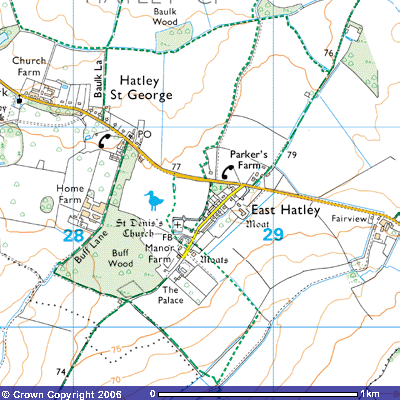
Footpath 9 is part of an ancient trackway
called Hayley Lane that ran south from Longstowe along the western side of the
medieval triangular village green of East Hatley to its apex at the (now
demolished) moated manor houses between Manor Farm and The Palace. It is a
continuation of Footpath 13 on the south side of the road that runs along the
rear gardens of the late-19th century houses on the village
street. It starts at about 78 metres
above sea level on the north side of Hatley Road, on the north-western edge of
the village. (TL 287507) and zig-zags round the edge of the field for about 300
metres until it turns east along the northern edge of the old village green. It
then meets up with a track, the original route in medieval times, that runs north-northeast for about 500 metres
down a slope to end where it crosses Millbridge Brook (TL 289516) at the
southeast corner of a plantation. Here it meets Footpath 7 which takes you west
alongside the brook towards Hatley St George or south east to meet Bridleway
18. Hayley Lane continues northeast as
Footpath 17 and Bridleway 3 towards Hayley Wood and Longstowe.