Permitted Footpath
Direction
NE then NW Distance c.600m.
![]()
![]()
![]() This
footpath allows you access to Gamlingay Wood. It has been provided by
This
footpath allows you access to Gamlingay Wood. It has been provided by
![]()
![]() It
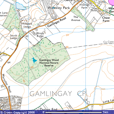
starts where Footpath 1 (TL) meets an old
farm track at about 54 m. above sea level (TL244527) and turns west round the
back of Dutter End towards the Waresley Road. The
path ascends the gentle SE facing slope of the valley NE towards Fuller’s Hill
Farm. On Thomas Langdon’s 1601 map of Gamlingay the track was marked as Snake
Hill. Grass snakes are quite
common and may be seen basking in the sun during the summer months. The
fields to the northwest were owned by Abr. Jacob Jo. Burgoyne Esqr. Sometimes the Abbot of Saltry (Sawtry)
and Avenelles..
It
starts where Footpath 1 (TL) meets an old
farm track at about 54 m. above sea level (TL244527) and turns west round the
back of Dutter End towards the Waresley Road. The
path ascends the gentle SE facing slope of the valley NE towards Fuller’s Hill
Farm. On Thomas Langdon’s 1601 map of Gamlingay the track was marked as Snake
Hill. Grass snakes are quite
common and may be seen basking in the sun during the summer months. The
fields to the northwest were owned by Abr. Jacob Jo. Burgoyne Esqr. Sometimes the Abbot of Saltry (Sawtry)
and Avenelles..
The north east boundary of the large field called ‘Short woode’ ‘Leaes comon’
has been planted with an avenue of trees which, in the future will be a
wonderful approach to Gamlingay Wood. The path goes northwest through this
avenue and meets the southern edge of the wood by a stile (TL244523). In the 17th
century it was called Avenelles Wood.. For details about the Avenel family click
on this hyperlink: Avenelles
Manor
In Gamlingay Wood there is a circular ditched
enclosure, about 40 metres wide with an inner bank (MCB16146 TL243535). The
area has been cleared in recent years so you can get an impression of the scale
of the site. Exactly when it dates from is unknown but there may have been a
settlement of some kind on the island. The surrounding ditch is largely
overgrown but a few stretches of water can be seen. The banks may have had a
wooden stockade when it was occupied.
Conservation
volunteering at Gamlingay Wood
Expansion
to create Sugley Wood
Species
found in Gamlingay Wood