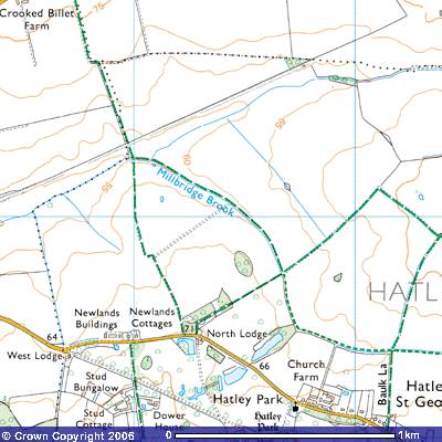
Bridleway 1 Hatley St George
Direction: roughly N – S;
Distance c800m.
![]()
![]()
![]()
![]()
![]()
![]() Bridleway 1 starts on the north side of Hatley
Road (272515) about 50 metres west of North Lodge, one of the gatehouses of
Hatley Park to the south. The OS map shows a spot height of 71 metres above sea
level. The farm track follows the western side of a small wood north along the
parish boundary between Gamlingay and Hatley. It is heavy clay soil on which
cereal crops are grown.
Bridleway 1 starts on the north side of Hatley
Road (272515) about 50 metres west of North Lodge, one of the gatehouses of
Hatley Park to the south. The OS map shows a spot height of 71 metres above sea
level. The farm track follows the western side of a small wood north along the
parish boundary between Gamlingay and Hatley. It is heavy clay soil on which
cereal crops are grown.
Thomas Langdon’s 1601 map drawn up for
Merton College, Oxford marked it as Perambulation or procession waye. This
was part of the route taken by parishioners when they were ‘beating the
bounds’. If you want to know more about Gamlingay’s Procession Waye you can
read a book on it in the library. The field to the west was owned in 1601 by
John St George, the major landowner in Hatley St George. The field to the east
was marked as Hatley Fielde. After about 300 metres there is a short
‘dog’s leg’ when the route passes a farm track to the east. The track continues
down the gentle slope for another 500 metres towards Millbridge Brook. This
stretch was also marked as Procession waye. There must have been a local
industry nearby as the field to the west was marked on the 1601 map as The brickkyllyon (sic) owned by The
Queen late the priory of St Ives.
Before the 1957 The County of Cambridge
(Parishes of Hatley and Gamlingay) Order, it was known as Bridleway 18. It was
transferred to Hatley and called Bridleway 1. It finishes at the boundary
between the parishes of Hatley St George, Little Gransden and Gamlingay at the
bridge over Millbridge Brook (270523) at 55 m. To the north you can see a long
embankment stretching ENE. Until the Beeching reforms of the railways in 1963
it was, the route of the Cambridge to Oxford railway line. The flat field on the
northern side of the brook was known in early 17th century as Broade
leae and was used as a gallop by the racehorses on Major Astor’s stud farm
in Hatley Park.
In 1839 some Roman coins were found in the
field to the east. As the nearest Roman settlements were in Everton and Sandy,
they may have been dropped by travellers or hidden as a hoard. Bridleway 2 follows the north-eastern
side of Millbridge Brook south-east up a gentle slope for about a kilometre
until it meets the junction of Bridleway 8 and Footpath 7 (277517). Bridleway 1
continues to the north as Bridleway 11
which runs for about 900 m. towards the Crooked Billet Farm, Fuller’s Hill Farm
and Gransden Lodge Airfield.