Bridleway 21 (East Hatley)
Direction roughly SSE – NNW Distance: c.1,700 m. Back to map
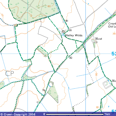
Bridleway 21 is a continuation of Bridleway 2
(Arrington) that runs roughly south-southeast to north-north-west along the
parish boundary between East Hatley and Arrington. It starts where Bridleway 3 meets the parish boundary
(TL 301518) at just over 80 metres above sea level. From here there are
panoramic views across the county as this area is the highest in West
Cambridgeshire. The land is heavy boulder clay, laid down during the last ice
age which only melted about 11,000 years ago. Beneath it lies many hundreds of
metres of Gault clay, deposited when this area was under the sea about 500
million years ago and about 27o south of the Equator.
For about 300 metres it follows
the edge of the field until it meets Bridleway 18, Croydon Old Lane (TL
299522). This ancient track takes you northeast on Bridleway 1 (Arrington) to
meet Ermine Street, the old Roman Road between Royston and Godmanchester or
southwest towards East Hatley. The parish boundary follows this track for about
800 metres before turning back towards the north-eastern corner of Hayley Wood.
About 250 metres to the
east is another medieval moat. Crossing the track, Bridleway 21 turns
west-northwest towards Hatley Wilds for about 200 metres when it meets
Bridleway 22 (TL 299521), perhaps the shortest in the county. It’s only about
200 metres long and is a short cut from Bridleway 18.
In 1307 there was
mention of ‘Wolds’ in the area north of the parish – open grassland used for
grazing sheep and cattle. It is thought that the angular shape of the fields
reflects the division of this common
land. The bridleway continues towards the medieval moat and manor house of
Hatley Wilds (TL 297523) According to the Royal Commission of Historic
Monuments
(12)
HATLEY WILDS (Class J; N.G. TL 296524). of one storey with attics, partly
framed and plastered, partly of brick, with tiled roof hipped at the S. end;
inside some chamfered ceiling beans are exposed; first half of the 18th
century.
(R.C.H.M. (1968),
Inventory West Cambs. p. 150)
Local stories tell of
there being a tunnel at Hatley Wilds leading to Longstowe church. Bridleway 21
then turns east for about 150 metres where you stand 81 metres above sea level.
The path then turns north-northwest and about 200 metres further you pass a
triangulation pillar (TL 296525), the white concrete block on top of which the
Ordnance Surveyors placed their theodolyte to determine the angles between key
features on the horizon and then use trigonometry to determine their distance
and altitude. What local landmarks can you see from here? Check the Ordnance
Survey map to find out.
After about a further
200 metres you cross a bridge over a drainage ditch and meet Bridleway 5 and
the parish boundary at the southeast corner of Hayley Wood. The bridleway then
continues north-northwest for about 500 metres before ending when it reaches
the corner of the parish boundary with Longstowe and Little Grandsen (TL
294533). Bridleway 6 runs east to west
from here along the parish boundary. The track, known as Hayley Lane, continues
north as Bridleway 15 towards Cooper Gate House on the old Cambridge to Oxford
railway line and the Longstowe Road.
Back
to map