Bridleway 3 (Hatley St George)
Direction: roughly SW – NE, then NW – SE Distance:
c. 1,500 m. Back to map
Bridleway
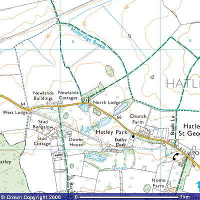
3 starts at 71 metres above sea level on the north side of Hatley Road,
opposite North Lodge, Hatley Park (TL 273525). There is a small lay-by where a
few cars can park. It follows the
eastern side of a small plantation north for about 100 metres and then veers
northeast alongside the wood for a further 250 metres before dropping gently
down towards the bridge over Millbridge Brook (TL 277517) where it meets the
junction of Bridleway 2 and Footpath 7. Bridleway 2 takes you
northwest towards Fullers Hill Farm and Little Gransden. Footpath 7 takes you
southeast back towards Hatley St George and East Hatley.
Bridleway 3
continues northeast up a gentle slope towards Hayley Wood, crossing a
footbridge over a drainage ditch (TL 279519) after about 300 metres. It
continues alongside a ditch for a further 400 metres when, at the field
boundary, it turns sharply to the southeast (TL 282522). The fields in this area
still retain evidence of the medieval open field system. According to the Royal
Commission of Historic Monuments: In the N. of the parish around N.G. TL
283521 parts of three furlongs running N.W. to S.E. and one running N.E. to
S.W. (a complete furlong with 25 ridges), all well preserved, are now combined
in one field.
(R.C.H.M. (1968), Inventory Vol. I, West Cambs. p. 151)
 The
bridleway now follows the side of the field for a further 400
metres until it meets Bridleway 5 (TL
288522). This track takes you north towards Hayley Wood and Longstowe but
Bridleway 3 turns south towards East Hatley. It follows the eastern side of a
drainage ditch for about 400 metres until it turns east at the corner of the
field (TL 289518). It then follows the northern side of a small plantation for
200 metres until it crosses a bridge and meets Footpath 17 which runs south into
East Hatley. Bridleway 3 continues northeast for about 300 metres along the
western side of the hedge until it turns southeast at the northern corner of
another small plantation (TL 292522). It then continues along the north-eastern
side of the trees for about 300 metres
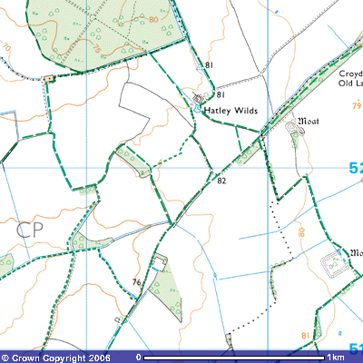
where it meets Footpath 19 (TL 294520) which leads northeast to Hatley Wilds.
The
bridleway now follows the side of the field for a further 400
metres until it meets Bridleway 5 (TL
288522). This track takes you north towards Hayley Wood and Longstowe but
Bridleway 3 turns south towards East Hatley. It follows the eastern side of a
drainage ditch for about 400 metres until it turns east at the corner of the
field (TL 289518). It then follows the northern side of a small plantation for
200 metres until it crosses a bridge and meets Footpath 17 which runs south into
East Hatley. Bridleway 3 continues northeast for about 300 metres along the
western side of the hedge until it turns southeast at the northern corner of
another small plantation (TL 292522). It then continues along the north-eastern
side of the trees for about 300 metres
where it meets Footpath 19 (TL 294520) which leads northeast to Hatley Wilds.
The Ordnance Survey map shows another footpath
at the end of the plantation heading west-southwest to meet up with Footpath
17. Bridleway 3 continues south-southeast
for another 400 metres until it meets up with Bridleway 18 where it meets the
source of Millbridge Brook at about 82
metres above sea level (TL 295517). Bridleway 18 takes you northeast up
Croydon Old Lane towards Hatley Wilds and Ermine Street near Kingston Wood or
southwest into East Hatley.
Back to map