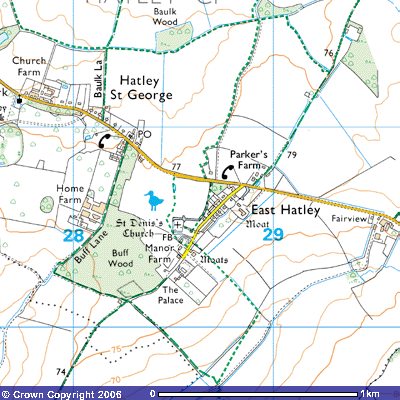
Footpath
13 (East Hatley)
Direction:
S - N Distance: c.300 m.
FP7 FP9 FP9 BW18![]()
Footpath 13 is an ancient trackway that ran
along the western side of the medieval village green of East Hatley. It starts
at about 76 metres above sea level on the north side of St Denis Church (TL
286505) and follows the rear gardens of houses on the village street. A
drainage ditch runs alongside it. According to the Victoria County History of
West Cambridgeshire:
In 1086 the vill (hamlet) had 21 peasants
and 3 servi (? slaves) (V.C.H. Cambs. v. 415-16). There were probably 19 taxpayers in 1327 (Cambs. Lay Subsidy, 1327, 47) and 23 for the wool levy in 1347 (Palmer, Hist. Clopton,
58-9. For 1377 population, cf. above, Croydon intro.). By the 16th century the
population had shrunk. There were 10 taxpayers in 1524 (P.R.O., E 179/81/129, m.2) and 9 households in 1563 (B.L. Harl, MS. 594, f. 198). The 10 or 11 houses of 1662 were reduced
to 8 by 1674 (P.R.O.
E 179/84/437, rot. 49; E 179/244/23, rot. 47). There were 50 adults by 1676 (Compton
Census), and 75 people in 17 families in 1728 (B.L. Add. MS. 5828, f. 90). Numbers were probably even lower c.1750
(C.R.O.,
par. Reg. TS). From
1801 to 1841 the population varied around 100, suddenly rising to 146 by 1846
by 1851. from a peak of 155 in 1871 it fell to 124 by 1891, fluctuating
thereafter between 70 and 100 until the 1950s (Census, 1801 – 1971).
The medieval village lay around a
triangular green, widening slightly from its south-eastern apex, by which stood
the church, parsonage and principal manor house. The green lay where a track
running north-east from Pincote hamlet in Tadlow divided to lead
north-north-east towards Hayley wood in Little Gransden, and north-east along
Long, or Croydon Old, Lane towards Longstowe. Along the two longer sides of the
green lay many small tofts (Viking word for house with building and land)
within moats often still wet, from which crofts (small farms) stretched back (R.C.H.M. Cambs. i. 149-52). After the final inclosure c. 1670 the
village was largely cleared away (to create sheep pasture). For some time the
only dwellings in the parish were eight farmhouses scattered through the
fields, such as the surviving timber framed Long Lane Farm, and Hatley Wilds
Farm, partly of brick, in the far north, and their dependent cottages (Ibid. 150; all illustrated
on Downing maps 1750).By
1750 there survived at the site of the village, then called Town closes, only
the parsonage and a farmhouse at each end of the green, incorporated as Walnut
Tree close into the Downing family estate (Downing maps 1750). The area round the green was almost
equally empty in 1842 (C.U.L.,E.D.R., G, tithe map 1842). Small houses began to be built actually
on the old green from the 1850s, and by 1871 the parish contained 6 farmhouses,
c. 12 cottages at the green, and the ‘Palace’, a high, gaunt house at its
south-west end, erected for members of Downing College to occupy while
supervising the College estate (P.R.O., RG 10/1577; Cambs. Ind. Press, 1st
Dec. 1961). In the
1970s c. 14 new houses filled a wide gap between the 19th century
housing at each end of the green (cf. Cambs. Evening News, 17th Oct. 1974;
4th Feb. 1977)…
Along the two longer sides
of the green lay many small tofts (Viking word for house with building and
land) within moats often still wet, from which crofts (small farms) stretched
back (R.C.H.M.
Cambs. i. 149-52). After
the final inclosure c. 1670 the village was largely cleared away (to create
sheep pasture)… By 1750 the survived at the site of the village, then called
Town closes, only the parsonage and a farmhouse at each end of the green,
incorporated as Walnut Tree close in the Downing family estate (Downing maps 1750). The area round the green was almost
equally empty in 1842 (C.U.L.,E.D.R., G, tithe map 1842). Small houses began to be built actually
on the old green from the 1850s, and by 1871 the parish contained 6 farmhouses,
c. 12 cottages at the green, and the ‘Palace’, a high, gaunt house at its
south-west end, erected for members of Downing College to occupy while
supervising the College estate (P.R.O., RG 10/1577; Cambs. Ind. Press, 1st
Dec. 1961)… In the 1970s c. 14 new houses filled a wide
gap between the 19th century housing at each end of the green (cf. Cambs. Evening News, 17th Oct. 1974; 4th Feb.
1977).
(V.C.H. West Cambs. Vol. II, pp.43-44)
The moat by Manor Farm was referred to in the Royal Commission of Historic Monuments:
(16) MOATED SITE (Class A1 (a); N.G. TL 285504), at Manor Farm
(Monument 6), on level boulder clay 260 ft. above O.D., being that of the manor
house of the Castell family demolished c. 1685 by the second Sir George Downing
(Lysons, Cambridgeshire, 201 and 209); the material was later used at Gamlingay
Park (see GAMLINGAY) (61), a rectangular area 200 ft. N.E. to S. W. by 100 ft.
is partly enclosed by a wet ditch 32 ft. to 45 ft. wide and 3 ½ ft. deep. This
has been partly filled but still complete in 1750 (map in Downing College).
There is a causeway 40 ft. wide across the S.E. side. At the S. angle is an
apparent approach leat (a man-made water filled
trench probably supplied by the drainage ditch running northeast to southwest
alongside the eastern edge of the village green), 2 ½ ft. deep still partly
wet.
(R.C.H.M. (1968), Inventory Vol. I, West Cambs. p. 150)
It also provided details of some of the older properties on the village street:
(7) HOUSES,
a pair, two-storeyed, of white brick with hipped thatched roof and a shared
central chimney; the N.E. house retains some of its original windows with
leaded lights in Gothic idiom; first half of 19th century.
(8) HOUSES, a pair, two-storeyed, of white brick, roof covered with modern pantiles, now one dwelling; the design approximates to Class J; first half of 19th century.
After about 300 metres Footpath 13 meets the Hatley Road (TL 287507) at about 78 metres above sea level and continues north on the opposite side of the road as Footpath 9.